Routes in the Alps
Le col de
l'Iseran
The route
One of the highest cols in Europe (2770 m), superb panorama over the
glaciers of Haute-Maurienne.
A little history
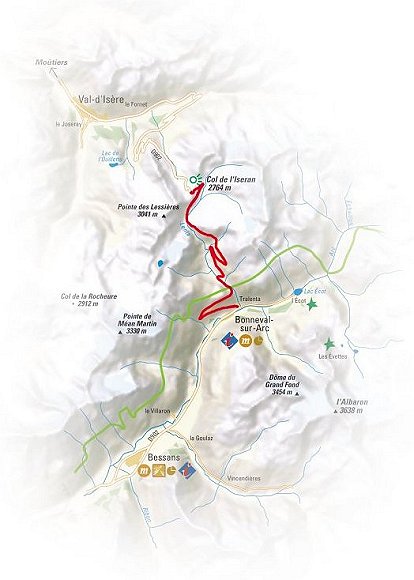
Delayed by the first world war, the col is opened to motor traffic in
July 1937 after 3 years of roadworks ; it provides a link with
Haute-Tarentaise and will be the last great work on the "route des
Grande Alpes" linking Geneva to Nice on PLM coaches.
The inhabitants of Bonneval, chamois hunters,
are reputed to be excellent guides.As early as 1860, Joseph Blanc
initiated his 4 sons, one of whom will guide an Englishman in the
Himalayas in 1910. Bonneval (distinguished as one of the most beautiful
villages in France) organizes each Friday a timed climb to L'Iseran.
What you should know
Ascent, overall : 970 m
Information : TO Bonneval-sur-Arc
Access : A43 exit 30, N6 to Lanslebourg then
D902.
Mont Cenis - Val
di Susa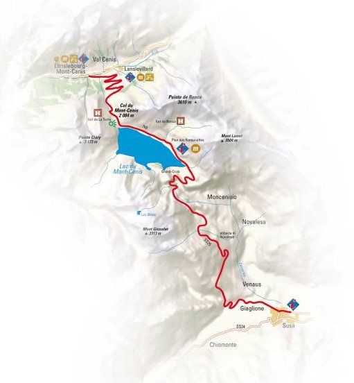
The route
First up the Mont Cenis road, then along the lake. Recommended stop at
the Mont Cenis museum and the EDF building on the side of the road, then
down to Italy via the Echelles hairpins.
A little history
Historical passageway, the Mont Cenis col was passed in winter by
travellers on sleighs ( "en ramasse") with the help of guides
("marrons"). In the XIth century, a hospice is built on the north side
of the lake, replacing the one built by Lothaire on the south bank in
825.
In 1578, the first rudimentary sleighs have
been improved. Napoléon even thought of building a town there, but it
will never be done.
A complex defensive system will be built
between 1877 à 1880, after the decommissioning of the Esseillon barrier
(see route 14). It comprised the forts of Cassa, Ronce, Pattacreuse,
Malamot and Variselle, the latter being the commandment fort. On the
French side, the fort de la Turra is so high that it is serviced by a
cable car, and it will survive World War 2's fierce fighting.
Technical prowess, the Fell railway linking
Saint-Michel-de-Maurienne and Susa was built between 1864 and 1868, but
was only used till 1871, when the railway tunnel was opened earlier than
anticipated and brought an end to the Fell railway. The old tunnels can
still be seen on the way down to Susa. The current gravity dam was made
between 1961 and 1969. Its crest is about 1400 m long and can be crossed
for a circuit around the lake.
What you should see
The Mont Cenis pyramid, the alpine garden, the Franco-Italian house.
What you should know
Ascent, overall : 2 266 m
Distance : 76 km
Information : TO Val Cenis, Maison
franco-italienne at the Mont Cenis col
Access : A43 exit 30
Col de la Madeleine
The route
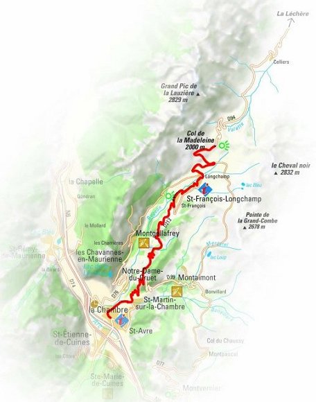
From La Chambre, the ascent begins with a beautiful succession or
hairpins and then progresses towards Saint-François-Longchamp, sometimes
in the shade.
You will ride past the fairy chimneys of
Montgellafrey (parking and signpost on the left before a sharp bend).
You can then choose to ride across
Saint-François 1450, to your right, or go straight up to Saint-François
1650.
A little history
Considered strategic by the regional authorities, the col was opened in
October 1949 to link Maurienne and Tarentaise.
Construction was achieved after several
phases and the col was inaugurated in July 1969 in the presence of the
savoyard minister Fontanet.
First passage by the Tour de France the same
year, and many times later, the Tour being a faithful visitor. Richard
Virenque was first in 1995, 1996 and 1997.
What you should see
From Saint-François to the col, the landscape is widely open, with
alpine grass, sheep and marmots. From the col, beautiful panorama over
the Lauzière, Cheval-Noir and Mont-Blanc massifs (in good weather
conditions).
What you should know
Ascent, overall : 1 550 m
Distance : 22 km
Access : A 43 from Chambéry exit 26 Ste Marie
de Cuines.
Restaurant : les 2 Mazots et la Banquise 2000
(at the col).
Télégraphe
and Galibier Cols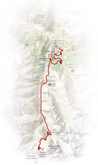
The route
Mountain and cycling lovers, the Galibier is a myth… It links Maurienne
to the Briançon region, and, more generally, the northern to the
southern Alps.
The road tunnel, too narrow, has been closed
since 1976. It will be reopened as soon as the current roadwork is
finished, and will allow the col to be opened earlier and closed later
in season and will free the final section from coaches and trucks.
At the Col du Télégraphe, a first stop will
reveal the panorama from the fort.
A little history
As many high points in the valley, the col was a relay for the Chappe
Paris-Milan imperial telegraph. Built in 1808, it enabled on sight
communication by signals. The fort today, built between 1885 and 1893,
guarded the strategic Galibier road and the military site in
Saint-Michel-de-Maurienne. Integrated into the Route des Grandes Alpes,
the road was traced in 1870 and opened to traffic in 1911, the year when
the Tour de France first passed the Galibier col. Émile Georget rode to
the top, setting foot on the road only to sign at a control point and
drink water, admitting that "it's the hardest thing I've done" !…
Jacques Godet said about the col : "It defines the value of a man…"
What you should see
2 646 meters high, the col du Galibier has an orientation table with an
almost circular panorama from the Mont Blanc, to the north, to the
Ecrins, Meije and Pelvoux in the south.
What you should know
Ascent, overall : 2098 m
Distance : 34 km
Access : A 43 exit 29 "St Michel de
Maurienne".
Tour de France 2018 Route
Stage 11 - Albertville - La Rosiere
The route
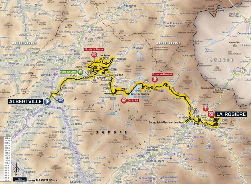
At 108.5 kilometres, the 11th stage of the Tour de France runs to
a summit finish in ski resort La Rosière. The riders start in
Albertville to tackle Montée de Bisanne, Col du Pré and Cormet de
Roselend as intermediate climbs. The final ascent to La Rosière is 17.6
kilometres at 5.8%.
Col de
Colombière and Col de Romme
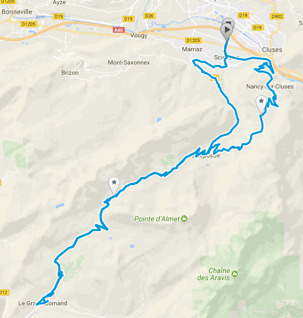
From the Cluses side this is one of the quietest,
picturesque yet toughest climbs you can find in the area. In terms of
average gradient this is harder than the Joux Plane albeit around 2km
shorter (3km of the official approach) and relative to the Joux Plane
the approach from Cluses has several really steep sections (well in
excess of 10%) balanced out by less steep sections of 6%-7%.
Col de Bluffy
The route
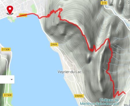
A varied itinerary with several lovely view points, with access towards
Lac d'Annecy if you want to find somewhere for dinner.
Col de la
Croix Fry and Col des Aravis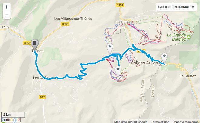
The route
The col de la Croix Fry is at 1477m in the Aravis range. It links the
valley of the river Fier, also known as the Manigod valley, with the
valley of the river Nom further to the North-East, and provides an
alternative route between Thônes and La Clusaz to the easier ride up
through Saint Jean de Sixt